Westborough and Dry Doddington, Stubton and Claypole DMMO 307 – Register of Definitive Map Modification Order (DMMO) applications.
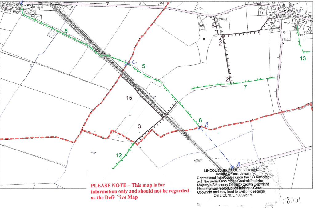
Summary: To upgrade to byway open to all Traffic (BOAT) Claypole public bridleway 8 and Stubton Roads Used as public paths 5 and 6, and to add a BOAT in Westborough and Dry Doddington.
DMMO number: DMMO 307
Intended effect of the application: Upgrade of Claypole Public Bridleway 8 and Stubton Roads Used as Public Paths (RUPPs) 5 and 6 to BOAT, and addition of BOAT in Westborough and Dry Doddington between the south-easternmost end of Stubton RUPP 6 and Clensey Lane.
Grid references for start and end of claimed route: SK854488 to SK870477
Principal cities, towns, villages near claimed route: Claypole, Newark on Trent (Notts)
Parish: Claypole, Stubton,Westborough and Dry Doddington.
District: South Kesteven
Applicant’s name: Alec Hill
Applicant’s address 17 Burton Road, , Heckington, Sleaford, NG34 9QR
Date of application: 19 March 2006
Council officer: Senior Definitive Map Officer
Application number: DMMO/307/WESTBOROUGH AND DRY DODDINGTON/STUBTON/CLAYPOLE
Council telephone number: 01522 782070
Council email: countryside_access@lincolnshire.gov.uk
Date of council’s decision: 2 July 2021
Outcome and reasons for the decision: Claypole Public Bridleway 8 is recorded in the 1771 Claypole Inclosure Award as a 60ft wide public highway called ‘Hough Road’ for ‘all persons to pass and repass on foot, horseback and with cattle and carriages’. The route subject to the application is consistently shown in historical maps as a ‘road’ or ‘lane’, and it is recorded as a public highway in the ownership of the Surveyors of Highways in the 1845 Boston, Newark and Sheffield Railway Plan. In taking into account the statutory extinguishment of unrecorded public motor-propelled vehicular rights by the Natural Environment and Rural Communities Act 2006 (“the 2006 Act”), this evidence is sufficient to reasonably allege the existence of a restricted byway between Stubton Restricted Byway 6 and Clensey Lane and over Claypole Public Bridleway 8, save the part which passes over the East Coast Main Line which vehicular rights were stopped up by the London and North Eastern Railway Act 1937, to warrant the making of a definitive map modification order. Stubton Restricted Byways 5 and 6 will be included in the order as documentary evidence when considered with the statutory extinguishment of public motor-propelled vehicular rights by the 2006 Act shows that they are already of the correct classification.
Date modification order made: 5 January 2022.
Completed: NO
Documents:
Westborough and Dry Doddington Stubton Claypole application 1
Westborough and Dry Doddington Stubton Claypole application 2
Westborough and Dry Doddington Stubton Claypole map