At the PC meeting dated 17 June, there was a minor discussion by one of the councillors regarding land ownership and the ambiguity associated with this.
I suggest the Parish Council subscribe to the appropriate software available to them, they could easily establish who owns what, and if they want more specific information they could ask Land Registry from the GR numbers available.
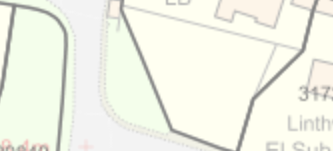
I have enclosed a cropped screen shot of one example to exclude Land Registry numbers (I did map the whole village – very interesting on how some properties are mapped). The triangular area where the flag pole, bench, Cherry Tree and flower beds are located belongs to Highways and not the village. Therefore the Cherry Tree (discussed at the meeting), if it is in poor condition is Highways responsibility and they should bare the cost of removal (if required) and not the village. However, I can see residents wishing to do this at their own cost.
Link to Land Registry: GOV.UK